

NavIC: How India's Own Navigation System Works and How It Differs from GPS and Google Maps
India is building its own navigation technology. But how does it work, which devices support it, and can it replace GPS or Google Maps? Let's understand the technology behind ISRO's NavIC.
Introduction: Does India Have Its Own GPS?
Think about your daily routine. You open Google Maps to find a restaurant, check the fastest route to your office or track a delivery. Within seconds, your phone identifies your location and guides you towards your destination.
But have you ever wondered how your phone knows where you are?
Most smartphones use satellite navigation systems such as GPS, developed and operated by the United States. However, India has developed its own regional satellite navigation system called NavIC (Navigation with Indian Constellation).
Developed by the Indian Space Research Organisation (ISRO), NavIC represents an important step towards India's independent space-based navigation capabilities.
But here is something interesting. NavIC is not another Google Maps. It is the technology working behind the scenes to provide location and timing information to compatible devices.
So, how does it work? Is it better than GPS? Will it work on Android and iPhones? And can it support navigation across all Indian cities?
Let's explore.
1. What Is NavIC?
NavIC stands for Navigation with Indian Constellation. It was earlier known as the Indian Regional Navigation Satellite System (IRNSS).
ISRO developed this system to provide India with an independent satellite navigation capability.
NavIC provides three important services:
-
Positioning: Identifying the geographical location of a person, vehicle or device.
-
Navigation: Helping users and systems determine direction and movement.
-
Timing: Providing highly accurate time information for systems that depend on precise synchronisation.
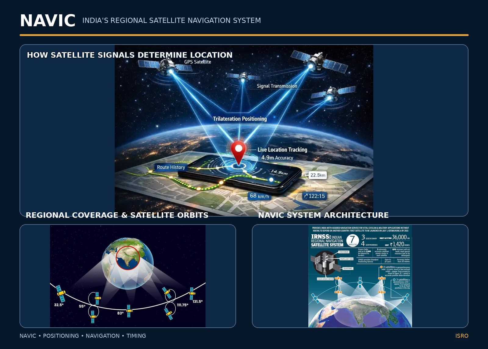
NavIC was originally designed around a seven-satellite constellation supported by a network of ground stations.
Its intended primary service area covers the entire Indian landmass and approximately 1,500 kilometres beyond India's geographical boundary.
This means its coverage is not limited to selected cities or metropolitan regions.
2. How Does NavIC Work?
NavIC works through three interconnected components: satellites, ground infrastructure and user receivers.
A. Space Segment: Navigation Satellites
Navigation satellites are positioned in geostationary and geosynchronous orbits.
They continuously broadcast signals containing information about their location and precise time.
A compatible receiver on Earth captures these signals and uses them to calculate its position.
B. Ground Segment: Monitoring and Control Stations
Satellites need continuous monitoring to maintain reliable navigation services.
ISRO operates ground infrastructure that performs several functions:
-
Monitors satellite positions and health.
-
Maintains accurate timing information.
-
Calculates and updates satellite orbit information.
-
Sends navigation data to the satellites.
-
Monitors the quality and integrity of navigation signals.
This infrastructure helps maintain the accuracy and reliability of the system.
C. User Segment: Receivers and Devices
This is the part most people interact with.
NavIC-compatible receivers are used in:
-
Smartphones.
-
Vehicle tracking systems.
-
Navigation equipment.
-
Fishing vessel tracking devices.
-
Transportation and industrial equipment.
-
Specialised navigation systems.
The receiver processes satellite signals and calculates the device's geographical position.
How Does NavIC Find Your Exact Location?
Let's understand the process through a simple example.
Suppose you are standing in Pune and your smartphone has a NavIC-compatible receiver.
-
Navigation satellites continuously transmit signals containing precise timing and orbital information.
-
Your smartphone receives signals from multiple visible satellites.
-
The receiver calculates the time taken by each signal to reach your device.
-
It converts the signal travel time into estimated distances from the satellites.
-
Using signals from at least four satellites, it calculates your three-dimensional position and corrects its internal clock error.
-
Your device provides the resulting location information to compatible applications.
This mathematical process is called trilateration.
An important point: Your phone does not need to transmit your location to the navigation satellites. The satellites broadcast signals, and your receiver calculates its position.
3. NavIC vs GPS vs Google Maps: What Is the Difference?
Many people use NavIC, GPS and Google Maps as if they mean the same thing. They do not.
GPS and NavIC are satellite navigation systems. Google Maps is a digital mapping and navigation application.
Here is a simple comparison.
| Feature | NavIC | GPS | Google Maps |
|---|---|---|---|
| Developed by | ISRO, India | United States | |
| Technology | Satellite navigation | Satellite navigation | Mapping application |
| Coverage | India and surrounding region | Global | Available in supported countries and regions |
| Main purpose | Positioning, navigation and timing | Positioning, navigation and timing | Maps, routes and directions |
| Internet for satellite positioning | Not required | Not required | Depends on map and app features |
| Device requirement | Compatible NavIC receiver | GPS-compatible receiver | Compatible smartphone and application |
Is NavIC Better Than GPS?
This depends on what we are comparing.
GPS offers global navigation coverage and has a well-established international ecosystem.
NavIC provides India with an independent regional navigation capability. It is designed around India's geographical and strategic requirements.
Its key advantages include:
-
Indigenous control over regional navigation infrastructure.
-
Additional navigation signals for compatible receivers.
-
Support for strategic and civilian applications.
-
Integration with other GNSS systems.
-
Greater independence in an important technology sector.
However, GPS currently has a much wider global ecosystem and established device support.
It is also important to understand that NavIC and GPS do not have to compete. Compatible receivers can use multiple satellite navigation systems together to improve positioning availability.
Can NavIC Replace Google Maps?
No. Both technologies perform different functions.
Think of it this way:
NavIC tells your device where it is.
Google Maps shows you where to go.
NavIC provides positioning information. Google Maps uses location information along with digital maps, road networks, addresses, traffic data and route calculations to guide users.
A compatible smartphone can use NavIC signals while running a mapping application, provided the hardware and software support them.
4. Which Indian Cities Will Have NavIC Coverage?
Here is an interesting fact: NavIC is not being introduced city by city.
Its intended coverage area includes the entire Indian landmass and approximately 1,500 kilometres beyond India's geographical boundary.
Therefore, cities such as:
-
Mumbai and Pune
-
Delhi and Chandigarh
-
Bengaluru and Chennai
-
Hyderabad and Vijayawada
-
Kolkata and Guwahati
-
Ahmedabad and Jaipur
-
Lucknow and Bhopal
-
Kochi and Thiruvananthapuram
-
Srinagar and Jammu
fall within its designed coverage region.
Small towns and rural locations are also included.
However, coverage design does not automatically guarantee reliable positioning at every location. Actual performance depends on the operational satellite constellation, signal visibility, receiver quality and surrounding environment.
5. Will NavIC Work on Android and iOS Smartphones?
This is one of the most practical questions for smartphone users.
The answer is yes, but with an important condition: your smartphone must have compatible navigation receiver hardware and software.
Android Smartphones
Several Android smartphones from different manufacturers support NavIC.
In February 2026, the Government of India reported that more than 60 mobile handset models from major global manufacturers supported NavIC positioning.
However, not every Android smartphone supports it.
Before purchasing a device, check:
-
The exact smartphone model.
-
NavIC compatibility in the technical specifications.
-
Supported GNSS frequencies.
-
Chipset and receiver capabilities.
Apple iPhones and iOS
NavIC support should not be assumed across all iPhones.
Compatibility depends on the GNSS receiver hardware and Apple's implementation of supported satellite navigation signals.
An iPhone supporting GPS does not automatically mean it supports NavIC.
Does NavIC Require Internet Connectivity?
No.
NavIC satellite signals are broadcast directly to compatible receivers. Your device does not require mobile data or Wi-Fi to receive these signals.
However, mapping applications such as Google Maps use additional information.
For example:
-
Live traffic requires internet connectivity.
-
Online address searches require internet connectivity.
-
Downloaded offline maps support navigation without continuous internet access.
So, satellite positioning and online mapping are two separate functions.
6. Where Can NavIC Be Used?
NavIC has applications across several sectors. Its importance extends far beyond personal smartphone navigation.
Transportation and Logistics
NavIC supports vehicle tracking, fleet management and transportation monitoring.
It helps organisations develop systems for tracking vehicles and improving operational visibility.
Indian Railways
Satellite navigation technology supports real-time train tracking and monitoring.
The Government of India reported in February 2026 that NavIC-enabled tracking was operational on more than 10,400 locomotives.
Maritime and Fishing Operations
NavIC-enabled receivers and transponders support fishing vessel tracking and emergency alerts.
This technology helps improve communication and safety for fishing communities.
Defence and National Security
Independent navigation infrastructure is important for strategic applications.
NavIC provides India with an indigenous navigation capability for authorised strategic users through its encrypted Restricted Service.
Agriculture and Surveying
Satellite positioning supports precision agriculture, land surveying, geographical mapping and resource monitoring.
Disaster Management
Location and timing information support emergency response, monitoring and coordination during natural disasters.
Telecommunications and Critical Infrastructure
Accurate timing is essential for synchronisation in telecommunications and other critical systems.
NavIC provides a source of Indian satellite-based timing information for compatible infrastructure.
7. What's New in NavIC? Understanding the Next-Generation NVS Satellites
ISRO is continuously working to strengthen India's navigation infrastructure through its next-generation NVS satellite series.
The NVS series is designed to improve service continuity and introduce additional capabilities.
One important improvement is the addition of the L1 frequency band alongside the existing L5 and S bands.
Why does this matter?
L1 is widely used by global satellite navigation systems. Its inclusion helps improve compatibility with modern multi-GNSS receivers and supports wider adoption in consumer devices.
Another important development is the use of an indigenously developed atomic clock.
Precise timing is essential for satellite navigation. Even a small timing error can affect the distance calculation and the accuracy of positioning.
Latest Development: ISRO Successfully Launches NVS-03
On 30 October 2026, ISRO successfully launched NVS-03 aboard the GSLV-F18 launch vehicle from the Satish Dhawan Space Centre in Sriharikota.
NVS-03 is the third satellite in India's next-generation NVS series.
It carries:
-
L1, L5 and S-band navigation payloads.
-
An indigenously developed atomic clock alongside procured clocks.
-
Navigation capabilities designed to strengthen India's regional satellite navigation infrastructure.
Following its launch, the first orbit-raising manoeuvre was successfully completed on 31 October 2026.
Further manoeuvres were planned to place the satellite in its designated orbital position.
This is an important development in India's efforts to strengthen NavIC. However, a successful satellite launch and full operational deployment are two different milestones.
8. Challenges and Limitations of NavIC
Every technology has challenges, and NavIC is no exception.
Understanding these limitations gives us a more realistic picture of the system.
1. Satellite Availability
A satellite navigation system requires a sufficient number of operational satellites to calculate positions reliably.
In a parliamentary reply dated 29 July 2026, the Department of Space stated that only three satellites were then providing NavIC positioning, navigation and timing services.
At least four operational satellites are required for basic standalone positioning.
NVS-03 was subsequently launched on 30 October 2026, but it was still undergoing orbital manoeuvres as of 2 November 2026. Its launch alone does not establish that standalone positioning services have been restored.
2. Smartphone Compatibility
Not all smartphones have NavIC-compatible receivers.
Wider adoption depends on chipset manufacturers, smartphone companies and software support.
3. Signal Visibility
Buildings, tunnels, dense urban structures and other obstructions can affect satellite signal reception.
This is a common challenge for satellite navigation systems, including GPS.
4. Wider Industry Adoption
NavIC needs continued adoption across smartphones, automotive systems, industrial equipment, logistics platforms and other navigation-based applications.
5. User Awareness
Many people are familiar with GPS but have limited knowledge of NavIC.
Greater awareness among consumers, developers and manufacturers will support its adoption.
9. The Road Ahead: Opportunities for India's Technology Industry
NavIC creates opportunities beyond satellite manufacturing.
It opens possibilities for Indian technology companies, startups, engineers and product developers.
Some important areas include:
Indigenous Navigation Receivers: Developing compatible GNSS chipsets, modules and embedded receivers.
Smart Transportation: Building vehicle tracking, fleet monitoring and intelligent transportation solutions.
AI-Based Location Intelligence: Combining satellite positioning with AI to analyse movement patterns, identify unusual activities and improve monitoring systems.
Defence Technology: Developing navigation-enabled systems for strategic and authorised applications.
IoT and Industrial Automation: Integrating location and timing information into connected devices and industrial equipment.
Smart Cities: Supporting location-based services, transport monitoring and infrastructure management.
For engineering and technology organisations, this creates opportunities to explore new products and solutions using indigenous satellite navigation capabilities.
The future of navigation will increasingly involve the integration of satellite systems, artificial intelligence, connected devices and real-time data.
Conclusion: A Step Towards India's Technological Independence
NavIC is an important part of India's journey towards developing independent space-based infrastructure.
It is not designed to replace Google Maps, nor does it need to replace GPS completely. Its purpose is to provide India with its own regional satellite navigation capability.
From smartphones and transportation to agriculture, maritime operations and national security, NavIC has applications across several important sectors.
With the next-generation NVS satellites, ISRO is working to strengthen the system and expand its capabilities.
The real opportunity lies in how Indian industries, engineers, startups and technology developers adopt this infrastructure to create practical solutions.
India is not only developing satellites. It is building the technology infrastructure to navigate its own future.


Recent Posts